UNESCO - WORLD HERITAGE SITES - ALGERIA
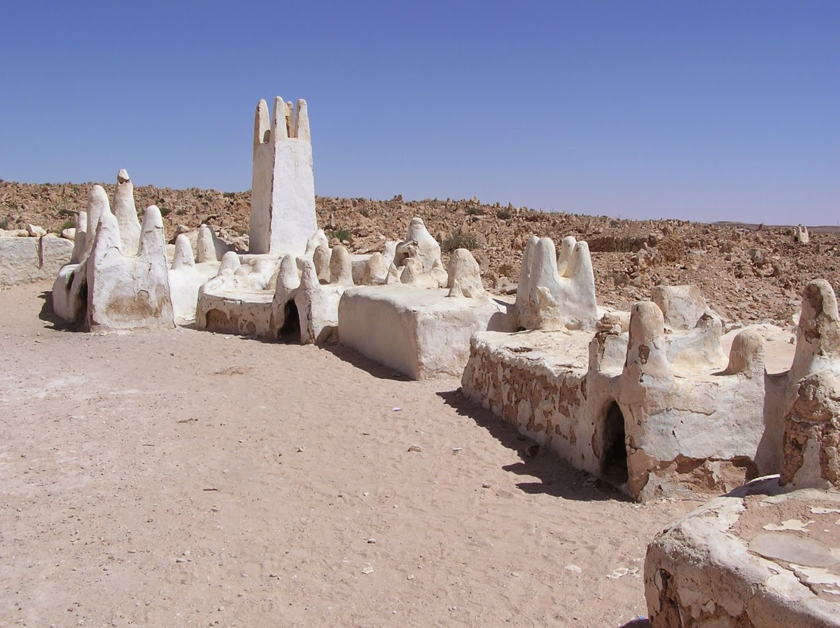
Al Qal'a of Beni Hammad
In a mountainous site of extraordinary beauty, the ruins of the first capital of the Hammadid emirs, founded in 1007 and demolished in 1152, provide an authentic picture of a fortified Muslim city. The mosque, whose prayer room has 13 aisles with eight bays, is one of the largest in Algeria.[whc.unesco.org]
Al Qal'a of Beni Hammad[source]
Al Qal’a of Beni Hammad ruins is the remnant of the first ancient Muslim City in Algeria. It is the vestiges of a former mosque which consists of 13 aisles and eight coves as its main features. The location of the ruins is only a kilometer above sea level. For a person who does not know what the previous attraction looks like, it will just give them an impression of a plain structure in the midst of a vast dusty land.[source]
Kalâa des Béni Hammad, Algeria[source]
-----
Djémila (Cuicul)
Situated 900 m above sea-level, Djémila, or Cuicul, with its forum, temples, basilicas, triumphal arches and houses, is an interesting example of Roman town planning adapted to a mountain location.[whc.unesco.org]
Septimius Severus Temple by Yelles[source]
Formerly known as Cuicul, Djémila is an ancient Roman colony founded during Nerva reign (96-98 AD) and provide a significant evidence of Roman history in Africa from 2nd to 6th centuries.It is one of the most beautiful Roman ruins and testament of a great Roman architecture and town planning.[source]
Ancient Roman theater in Djemila by Yelles[source]
Christian quarter by harmony lameche[source]
-----
M'Zab Valley
A traditional human habitat, created in the 10th century by the Ibadites around their five ksour (fortified cities), has been preserved intact in the M’Zab valley. Simple, functional and perfectly adapted to the environment, the architecture of M’Zab was designed for community living, while respecting the structure of the family. It is a source of inspiration for today’s urban planners.[whc.unesco.org]
Ghardaïa, M'zab, Algeria. by Joachim Himmeröder[source]
The M’zab Valley is an oasis in the Sahara desert. Located about 500 kilometers south of Algiers in the Ghardaia province of Algeria, the 10-kilometer-long valley. The M’zab Valley has been inhabited since 1012, when M’zabite Berbers, a fiercely independent group of Ibadiyy Muslims, moved to the region in an attempt to escape robbers and persecutors. The M’zabites settled in the valley because it could be easily defended.
M'Zab Valley[source]
-----
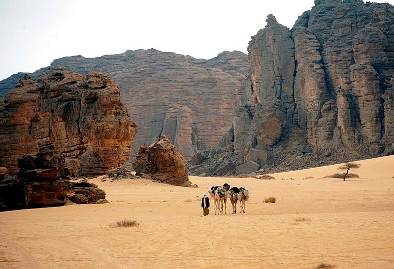
Tassili n'Ajjer
Located in a strange lunar landscape of great geological interest, this site has one of the most important groupings of prehistoric cave art in the world. More than 15,000 drawings and engravings record the climatic changes, the animal migrations and the evolution of human life on the edge of the Sahara from 6000 BC to the first centuries of the present era. The geological formations are of outstanding scenic interest, with eroded sandstones forming ‘forests of rock’.[whc.unesco.org]
Caption Painting Of Herdsmen And Cattle, Tassili N Ajjer, Algeria[source]
Tassili-n-Ajjer in Algeria is one of the most famous North African sites of rock painting. Its imagery documents a verdant Sahara teeming with life that stands in stark contrast to the arid desert the region has since become. Tassili paintings and engravings, like those of other rock art areas in the Sahara, are commonly divided into at least four chronological periods based on style and content.[source]
Algerian desert - Tassili National Park[source]
[source]
-----
Timgad
Timgad lies on the northern slopes of the Aurès mountains and was created ex nihilo as a military colony by the Emperor Trajan in AD 100. With its square enclosure and orthogonal design based on the cardo and decumanus, the two perpendicular routes running through the city, it is an excellent example of Roman town planning.[whc.unesco.org]
Roman ruins of Timgad[source]
Timgad, called Thamugas by the Romans, was a Roman colonial town in North Africa founded by the Emperor Trajan around 100 AD. The ruins are noteworthy for being one of the best extant examples of the grid plan as used in Roman city planning.[source]
Roman Theater[source]
Timgad-Algeria[source]
-----
Tipasa
On the shores of the Mediterranean, Tipasa was an ancient Punic trading-post conquered by Rome and turned into a strategic base for the conquest of the kingdoms of Mauritania. It comprises a unique group of Phoenician, Roman, palaeochristian and Byzantine ruins alongside indigenous monuments such as the Kbor er Roumia, the great royal mausoleum of Mauretania.[whc.unesco.org]
Roman ruins in Tipasa, Algeria[source]
Phoenician merchants established Tipasa on Algeria's western Mediterranean coast in the sixth century B.C., but the city did not reach its apex until the second and first centuries B.C. When it was annexed to the Roman Empire in A.D. 40, Emperor Claudius granted residents Jus Latii (rights of fellow Roman citizens). Over the centuries, Tipasa suffered assaults from Berbers and Vandals and was abandoned in the sixth century after a brief revival under the Byzantines.[source]
Tipasa remainings[source]
Vestiges of the Christian church[source]
-----
Kasbah of Algiers
The Kasbah is a unique kind of medina, or Islamic city. It stands in one of the finest coastal sites on the Mediterranean, overlooking the islands where a Carthaginian trading-post was established in the 4th century BC. There are the remains of the citadel, old mosques and Ottoman-style palaces as well as the remains of a traditional urban structure associated with a deep-rooted sense of community.[whc.unesco.org]
[source]
The Kasbah of Algiers is at the heart of the city of Algiers, located on a huge crescent bay hemmed in by steep hills and facing north over the Mediterranean. The Kasbah spreads up a hillside above the port to a hill-top citadel, a warren of narrow winding alleys and densely packed white-washed houses.[source]
[source]
Have a nice trip!


No Comment to " UNESCO - WORLD HERITAGE SITES - ALGERIA "